
Signal to Pakistan? US Trade Envoy Shares Map Showing All of J&K as Indian Territory. In a move that has sent shockwaves through South Asian diplomatic circles, the United States Trade Representative (USTR) has released an official map depicting the entire region of Jammu and Kashmir, including Pakistan-occupied Kashmir (PoK) and Aksai Chin, as sovereign Indian territory.
The map was published on Saturday, February 7, 2026, as part of the formal communication surrounding the newly unveiled India-US Interim Trade Agreement. While the focus of the announcement was on tariff reductions and market access, the cartographic representation—devoid of the usual dotted lines, “disputed” labels, or annotations—is being hailed in New Delhi as a monumental shift in Washington’s foreign policy.
A Departure from Decades of “Dotted Lines”
Signal to Pakistan? US Trade Envoy Shares Map Showing All of J&K as Indian Territory.For decades, official US government maps, typically issued by the State Department, have used specific visual cues to represent the sensitive borders of the Indian subcontinent. Traditionally, these maps featured dotted lines or shading to acknowledge the competing claims of Pakistan and China.
The new map, however, presents a unified Indian territory.
· PoK and Gilgit-Baltistan: Shown firmly within India’s borders.
· Aksai Chin: The region in eastern Ladakh under Chinese control since 1962 is likewise depicted as part of India.
· Arunachal Pradesh: Fully integrated into the Indian map, countering Beijing’s frequent claims on the state.
While India has always maintained that J&K is an “integral and inalienable” part of its territory, the explicit recognition by the world’s leading superpower carries massive strategic weight.
The Strategic Reset: Why Now?
The timing of this release coincides with a significant “reset” in India-US relations under the Trump administration. Just months ago, trade ties were at a low point after Washington imposed 50% tariffs on Indian goods, citing concerns over India’s purchase of Russian oil.
The breakthrough on the Interim Trade Agreement includes several major shifts:
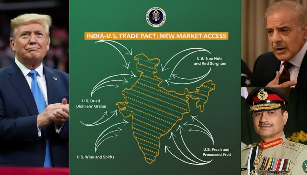
· Tariff Cuts: US tariffs on Indian goods have been slashed from 50% to 18%, a rate now more favorable than those applied to regional competitors like Pakistan (19%) and Vietnam (20%).
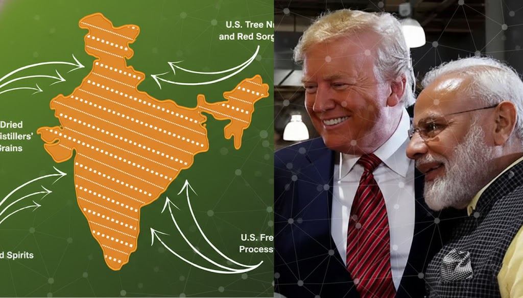
· Energy Pivot: India has committed to a massive $500 billion purchase plan for US energy, technology, and agricultural products over the next five years, signaling a shift away from Russian crude.
· Market Access: The deal opens doors for American farmers to export “tree nuts, dried distillers’ grains, red sorghum, and fresh fruit” to the Indian market.
Analysts suggest the map may be a deliberate diplomatic signal—a “reward” for India’s pivot toward US energy and a direct message to Islamabad, which has recently intensified its own lobbying efforts in Washington.
“Red-Faced” in Islamabad and Beijing
Signal to Pakistan? US Trade Envoy Shares Map Showing All of J&K as Indian Territory.The map’s release is particularly awkward for Pakistan. Its army chief, Field Marshal Asim Munir, has visited the US three times in the last six months, meeting with President Trump as recently as June to seek a closer relationship. Seeing Washington cartographically align with India’s claims on PoK is being described by commentators as a “diplomatic nightmare” for the Pakistani establishment.
Similarly, the inclusion of Aksai Chin as Indian territory is a direct thumbing of the nose at Beijing, occurring at a time when the US and China remain locked in their own trade and security tensions.
Expert Insight: “Full marks to the US for the map. This is a massive departure from the standard US stand and a clear acknowledgment of India’s territorial integrity,” said Major Gaurav Arya (Retired) on social media.
What This Means for Global Diplomacy
While some skeptics argue the map could be a bureaucratic oversight, the fact that it was published alongside a major policy document suggests a high level of intentionality. It effectively ends the “de-hyphenation” era and suggests a new, more muscular alignment between Washington and New Delhi.
For India, the map is a symbolic victory. It reinforces the stance that its borders do not require external validation, yet having that validation from the US provides significant leverage in international forums where Pakistan and China attempt to raise the “Kashmir issue.”
As India and the US move toward a final Bilateral Trade Agreement (BTA) by mid-March, one thing is clear: the map has spoken, and its message is loud and clear.
Disclaimer: This information is based on various inputs from news agency.